
- Category: Space Y News
- 2025-10-14
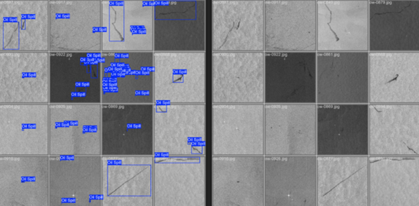
To support authorities to promptly intervene in case of oil spills, INECO is developing a solution integrating satellite imagery and AI with other technologies to spot pollution, foresee its provenance and direction, and identify the polluters.
Port and coastal authorities do not need to acquire additional equipment to operationally use the service, which will be based on a web portal that automatically downloads and processes satellite images to spot oil spills in coastal or maritime areas.
Authorities need timely information in case of oil spills at sea
To respond effectively to marine pollution, in particular oil spills, authorities must receive early warnings, allowing them to act before the spills reach the shore, where cleanup is far more costly. Beyond environmental damage, oil spills pose serious risks to coastal economies, especially in regions reliant on tourism and fishing industries.
The European Maritime Safety Authority (EMSA) delivers near-real-time alerts based on radar imagery captured by the Sentinel-1 Copernicus satellites. While highly valuable, the service has its limitations due to the sole use of radar images, and authorities need complementary technologies to ensure timely, effective response in case of oil spills and to pursue polluters.
INECO is building a web portal powered by satellite data and AI
PURSUIT (Platform Using Remote Sensing for Uncleanliness Intermaritime Tracking) is one the proposals selected through the 2025 Innovation Call of INECO, a public engineering and consultancy company owned by the Spanish Ministry of Transport and Sustainable Mobility.
The project integrates different technologies to offer pollution managers an intuitive and flexible platform that can be adapted to their needs to make them aware of oil spills as soon as possible.
PURSUIT relies on the European public Earth observation programme Copernicus, leveraging radar and optical data from Sentinel-1 and Sentinel-2 satellites, AIS (Automatic Identification System) positioning data (via GNSS), and tidal models. Advanced AI-driven algorithms automatically combine these data to detect, classify, and track pollution in coastal and marine areas and ports.
All data will be made available to port, coastal and environmental authorities by means of a simple web viewer, indicating the location of oil spills, their expected movements and probable origin. Thanks to the integration to vessels’ AIS, authorities may determine the polluters and take legal action against them.
The service will be tested by the Huelva Port Authority, which has been involved since the start of the project, and its testing could be extended to the Gulf of Cadiz, an area characterised by intense vessel traffic.
A cost-effective solution to protect the environment
PURSUIT offers a cost-effective, customisable and sustainable solution to environmental authorities, providing them with timely and reliable information to intervene in case of oil spills at sea.
The service can be used by authorities without the need to acquire additional equipment, storing data and processes in the cloud.
Compared to the information already offered by EMSA, PURSUIT will provide an interactive web portal, not only enabling authorities to identify oil spills, but also giving indications on their provenance and their future spread and direction. By integrating data from different satellites, the service is able to acquire images with a higher temporal and spatial frequency, allowing for the early identification also of small spills nearby the coast.
Moreover, by using the GNSS information of the vessels’ automatic identification system, PURSUIT provides law enforcement authorities with data useful to identify and pursue polluting vessels, offering an effective tool for environmental protection.
Future developments
The PURSUIT platform will be proposed to clients or integrated into other R&D and projects carried out by INECO to support environmental monitoring, expanding their scope or capabilities.
Even though the system currently leverages Copernicus open data, data from additional satellite constellations could be integrated in the future, increasing both the time frequency availability and accuracy of the information.
Implementation Timeline
The project is foreseen for a duration of 12 months, from April 2025 to April 2026.
Intended users
- Coastal authorities
- Environmental managers
- Port managers
To know more, visit the INECO website at https://www.ineco.com/
![]()
For more information about the PURSUIT project, visit: https://www.ineco.com/ineco/en/communication/news/innovating-ocean-tracking-pollution-ports-and-coastal-areas
![]()