- Category: Members News
- 2025-05-20
NAVAIDs are navigational aids comprising markers, signals or electronic devices designed to provide guidance and postion information to aircraft en route to their destination. In aviation, the accurate calibration of navigational aids is critical to ensure the safety and efficiency of air travel.
Indeed, signals in space transmitted by ground NAVAIDS need to be calibrated to ensure that they transmit accurate information to the aircraft during flights.
Traditionally, this calibration process involved complex and costly flight operations. However, using the latest drones and GNSS technology, Ineco, a Spanish public engineering and consultancy company of the Ministry of Transport and Sustainable Mobility, is transforming this critical task.
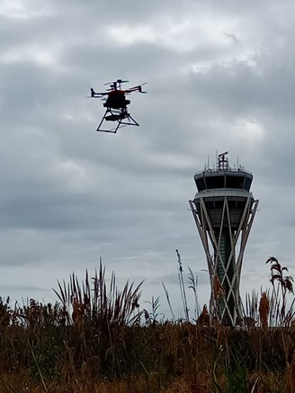
Ineco’s new service uses drones to calibrate NAVAID, providing a more efficient and cost-effective solution compared to traditional methods.
The service involves the use of Unmanned Aerial Systems (UAS) to perform flight testing and calibration of NAVAIDS. The drones are equipped with advanced GNSS technology to ensure precise positioning and accurate calibration.
Challenges addressed by the space-based service
The introduction of drone technology addresses several key challenges in the field of NAVAIDS calibration:
- High costs: traditionally, NAVAIDS calibration was performed by using flights, which required high costs in terms of time, resources and money.
- Impact on air traffic: traditional calibration flights can disrupt regular air traffic.
- Insufficient accuracy of calibration: real-time signal analysis capabilities and precise GNSS-based positioning are needed on board flights. Indeed, an insufficiently accuracy of the calibration could cause errors in the positioning and navigation of flights.
Benefits of the space-based service
Ineco’s innovative use of drones for NAVAIDS calibration offers numerous benefits:
- Reduced costs: by minimising the need for dedicated calibration flights, the automated drone-based service significantly reduces the overall operational costs associated with NAVAID calibrations.
- Automation of engineering flights: the use of drones automates the calibration process, reducing the need for manual intervention and specialised piloted flights.
- Minimised impact on air traffic: the use of drones reduces the need for dedicated flights just for NAVAID verification, hence minimising the impact of calibration operations on air traffic and ensuring smoother operations.
- Real-time signal analysis: equipped with real-time signal analysis capabilities, drones enable immediate data collection and analysis.
- Precise positioning: using RTK and Galileo High Accuracy Service (HAS) technology, drones achieve precise real-time positioning for accurate NAVAID calibration.
Implementation Timeline
The service is currently undergoing validation, with full implementation expected soon.
Intended users
- Air navigation service providers
- Airport operators
Ineco’s deployment of drones for NAVAIDS calibration marks a major advancement for the aviation sector. By integrating advanced GNSS technology and innovative drone applications, Ineco is providing a service that improves the accuracy, efficiency and cost-effectiveness of NAVAIDS calibration. As this service undergoes final validation and becomes fully operational, it promises to revolutionise the way air navigation service providers manage and maintain their navigation aids, ensuring safer and more efficient airspace.
To know more, visit the Ineco website at https://www.ineco.com/
![]()